


Main Highlights:
- Google Maps has been temporarily disabled in Ukraine to protect users during the country’s invasion by neighboring Russia.
- The features utilize anonymized location data from Android devices to highlight which routes are suffering delays and which bustling businesses and outlets.
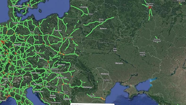
- One open-source intelligence (OSINT) professional saw signs of the Russian invasion on Google Maps early last Thursday after seeing strange “traffic bottlenecks” near the Ukrainian border.
- While access to the features has been blocked globally, Google states that drivers in the region who use turn-by-turn navigation will continue to have access to up-to-date traffic information.
Google Maps has been temporarily blocked in Ukraine to safeguard users’ safety while the country is invaded. The features use anonymized location data from Android handsets to indicate which routes are experiencing delays and which shops and retailers are bustling. According to experts, such data might shed light on the invasion’s progress. According to one open-source intelligence (OSINT) specialist, he saw signals of the Russian invasion early last Thursday after seeing odd “traffic bottlenecks” near the Ukrainian border on Google Maps.
Professor Jerry Lewis of the Middlebury Institute’s OSINT division told Motherboard last week that they believe they were the first to see the invasion. And they discovered it using a traffic app.
According to Reuters and Vice, Google stated that the decision to suspend these functions was taken to ensure the safety of local users. While worldwide access to the features has been restricted, Google claims that drivers using turn-by-turn navigation capabilities in the region will continue to access current traffic information. It is unknown whether Google has ever deactivated these capabilities in the past during crises or wars.
Location data gathered by mapping firms frequently reveals this kind of surprising discovery. For instance, when fitness tracking service Strava published a map of its users’ activities in 2017, it unintentionally disclosed the locations of multiple US military outposts, indicating where soldiers had been doing circuits around airfields. Similarly, Snapchat’s geolocation tools have captured photographs and videos from the Iraq War’s frontlines. And, with or without location data, material published on social media in warzones has developed into a critical tool for open-source investigators, journalists, and others.
Typically, this data must be coupled with information from other sources to produce useful information. For example, when investigators discovered traffic congestion outside of Ukraine last Thursday, they analyzed the region using satellite images. The smartphone data originated most likely from citizens stopped at checkpoints, not from the military equipped with Android phones.
Last week, Lewis, an OSINT investigator, told Motherboard that he believes big data corporations frequently avoid confronting how valuable their data may be. And they mean, when they do it, isn’t it cool? Perhaps it would be less remarkable if the Russians were capable of something akin to spotting an attack by Ukrainians.
What Is Traffic Information?
Traffic data is geolocated data that is timestamped and specifies the speeds and directions at which cars are traveling on a given highway or region. Traffic data has a variety of applications in innovative city traffic management, mapping, navigation, route planning, urban planning, and location intelligence.
Significant Benefits from Traffic Data Collected from Connected Cars-
Many automobiles offered nowadays are linked, which means they are electronic and networked. These automobiles may create vehicle data, which has several advantages when used in conjunction with conventional data gathering methods such as aftermarket devices or cellular data:
- They do not require additional hardware in the car, as fleet-based systems or electronic toll transponders do today, nor do they require embedded induction loops in the road.
- They are less sophisticated and exact than floating cellular data obtained from mobile phones, which must be triangulated and may include data from persons walking, bicycling, or taking public transportation.
- Utilizing technology such as the Otonomo Data Services Platform, the data may be quickly de-identified for specific use cases.


